A Quick Tour of
Preston County, West Virginia
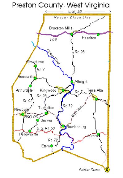
Preston County, bordering Pennsylvania to the north and Maryland to the east, has an area of 651 square miles and a population of 30,115 (2005). Traveling east on Route 7 from Morgantown (elevation 947 feet), you go generally "up hill" as you ascend the western face of the Allegheny mountain range. Masontown (elevation 1,800 feet).
At the four way stop in Reedsville (elevation 1,820 feet), turn left to continue on Route 7 to the county seat Kingwood (elevation 1,863 feet). Each autumn thousands of people pour into Kingwood to enjoy the Preston County Buckwheat Festival. This four day event, which always starts on the last Thursday in September, is sponsored by the Kingwood Volunteer Fire Department.
Just outside of of Kingwood you will cross the Cheat River and climb Caddell Mountain to Terra Alta (elevation 2,559 feet). Terra Alta Elementary and East Preston Middle School share the same campus with the majority of the complex having been constructed in the last 30 years. The main building dates from 1925 as Terra Alta High School. Alpine Lake Resort is nearby, a multi-million dollar four-season resort and conference facility with complete lodge facilities, golf course, boating, and skiing in season. Also nearby is Hopemont State Hospital, formerly the state tuberculosis sanitarium, dating from the time when it was believed that mountain air was therapeutic for tubercular patients. Northeast of Terra Alta is located Cranesville Swamp, one of the first National Natural Landmarks to be designated by the National Park Service in 1965.
Interstate 68 runs east-west through northern Preston County. From Morgantown, I-68 takes you across Cheat Lake and up Cheat Mountain to Cooper's Rock State Forest (elevation 2,100). There you descend into Preston County and an area of rich rolling farm land. The Bruceton Mills (elevation 1,549 feet) area has enjoyed some growth in recent years as a result of its close proximity to I-68. Bruceton School, serves K-8 students in the northern portion of Preston County. A large tract of land off I-68 near Hazelton (elevation 1,884 feet) is the site for the USP-Hazelton prison.
U.S. Route 50, said to be the last of the non-interstate coast-to-coast U.S. routes, winds through southern Preston County. Traveling east from Grafton, you pass through Fellowsville, across Laurel Mountain, down to the Cheat River, and then up Cheat Mountain into the mountain town of Aurora (elevation 2,600 feet). Fellowsville Elementary is a K-5 facility serving students from both the Fellowsville and Newburg areas. Aurora School, destroyed by fire May 10, 1993, has been rebuilt and currently is a K-8 facility. Nearby Cathedral State Park preserves a small authentic sample of the splendid timber which once dominated most of West Virginia.
State Route 92 is a north-south corridor. From Route 7 at Reedsville, Rt. 92 south takes you through the "Valley" area, a high valley at the foothills of the Allegheny mountains. You travel through historic Arthurdale, a re-settlement community formed by the federal government during the Roosevelt administration under the watchful eye of Eleanor Roosevelt. Intensive efforts are underway to preserve and restore the various buildings in the community in view of the area's significance in the politics of the "New Deal" era.
Newburg (elevation 1,230 feet), whose economy has been linked to the coal and railroad industry, saw its heyday in the days of the coal fired steam locomotive. A main east-west B&O railroad line passes through southern Preston County, and the histories of Newburg, Tunnelton, and Rowlesburg are closely linked to railroads and coal.
Route 26 runs north-south, through Bruceton Mills, Albright, Kingwood, and on through Tunnelton, Denver, and Fellowsville on Rt. 50. The latter three towns also have close links to the coal and railroad industry. Tunnelton (elevation 1,829 feet) is named for the B&O railroad tunnel in the vicinity, the longest on the entire system. Route 72 follows the course of the Cheat River. Traveling north on Rt. 72 from Rt. 50, you will pass through the river town of Rowlesburg (elevation 1,441 feet). Rowlesburg suffered extensive damage by the flood of 1985, and the K-12 school there was disabled. A new K-8 school was rebuilt as Rowlesburg School. Route 72 hugs the banks of the Cheat River to Rt. 7 at the foot of Caddell Mountain, providing for a most picturesque drive. On Route 72 south of Rowlesburg you will find the Comsat Earth Station at Etam. This facility has four antennae, with diameters of 9.2, 18.5, 32. 3 and 46 meters, and has the highest traffic volume within the Intelsat system. Etam is rarely found on roadmaps, but does figure in to the history of the Internet.
The Cheat River "narrows," just north of Rowlesburg, and is a popular spot for white water enthusiasts. The Cheat River Canyon, a virtually impenetrable canyon beginning at Albright and running to the northwest corner of Preston County, is said to hold some of the most challenging white water in the eastern United States. (Note: Unless you are experienced in white water sports, it is highly recommended that you consult with any of the fine Whitewater Rafting Companies in the area before you test the Cheat!).